Can’t go to the beach? We’ll drop a little on you

The cold front went through, did you notice? It’s moved south, about a Pueblo to Gardner, Kansas line now, around 7am. The jet sort of fell apart, largely over Canada right now with a trough Billings-Las Vegas kind of acting like the body part it looks like, a lot of disturbance aloft across the west. On the ground here, a moist and cool airmass followed the cold front in, extending now from the Palmer Divide across the northeast quadrant of the state. A lot of wet, some disturbance, a little heat. Those Storm Prediction Center people, working all night, say a slight risk of severe thunder bumpers to the south and east of Denver and a marginal risk along the front range, I-25 corridor and northeast plains.   

So, we’re looking at seeing some bumpers get started pretty early, around 1 along the foothills up Boulder way, spreading south to the Parker Divide and moving east reaching DIA by 3. Not calling for hail yet, a little weather dance to some CCR might keep it that way. Meanwhile, they are predicting hail to show down toward Colorado Springs, around 3. Other side of the Parker Divide, that high ridge stretching out into the plains really does generate a lot of our weather.

We’ll dry from west to east, Bumpers done with Boulder by 5, south metro by 6 and DIA by 7. They’ll persist in points east of us on into the night.  

We’re easing into a normal summer pattern for the next few days, normal temps, nice mornings, few bumpers in the afternoons. There will be a string of surface troughs form and move east along the east side of the mountains, caused by westerly flow aloft across the mountains curling into the extra space afforded them east. The circulation around a low pressure trough in this hemisphere is counter-clockwise, known in the biz as Cyclonic. It draws air from the higher pressure outside toward the lower pressure in the center of the trough. Coriolis–earth spinning–gives it a little twist so it pulls whatever is down over Texas into the front range, which is gulf coast moisture. So, the rain hitting your head in the afternoons has spent more time at the beach lately than you have, enjoy it.

(To leave a comment, click on the post title)

Thursday Morning. Nice day, some small drama Friday

Gonna be another cooker, kiddo, with temps into the 90s. Some thunderstorms coming off the higher terrain after 3, high based stuff, shouldn’t see severe over the metro. Maybe out in the plains we’ll see a severe get going someplace, knock around a few jackrabbits. A few will hang around the metro and east later than normal, there’s a surface front pushing in from Wyoming overnight to keep the churning going. The jet has curled well north of us, with an upside down horseshoe bent down west of us over Cali/Wash.

Friday’s the story, not a big one though. Kind of a “Huh” when you get to the conclusion. The cold front pushing in overnight is a weak one, but it will gets thing churning a little. Initially it’ll bring the winds out of the north but as it moves beyond us they’ll swing to the east. Which is upslope. The air is moving up over rising land so pressure is coming off, reducing the air’s capacity to hold dissolved moisture and water goes from gas to liquid, becomeing visible. Clouds. Churn them a little, heat the outer edges and that part of it climbs to higher cooler levels, releasing more moisture, gets pulled toward the middle of the cloud because THAT wet air got cooler with altitude and fell back down, then gets warmer lower and is pulled back to the outside etc etc etc, When the falling center column of air gets too heavy with wet and cold to turn around and go back up it splatters all over the ground. If it had a long time of going round and round some of the moisture froze and picked up a new layer of water lower when it turned around. That’s why you can break a hailstone apart and see rings, like a tree. Count them, that’s how many trips it made up and down before it whacked your begonias.

So, at the moment the Storm Prediction Center (yes, a real place full of hard working civil servants) has all of Eastern Colorado under a marginal risk of severe T-bumpers tomorrow afternoon and evening. Enough water out there to get some locally heavy rain. Flash flood stuff might happen, they’ll get a good forecast on that as we get closer.

After Friday we’ll be typical late June; nice mornings, a few bumpers moving off the mountains in the afternoons. Back into high 80s Saturday then 90s. 

Wednesday afternoon, Care Bear clouds

A lot of pretty fluffy things over the metro, convective, fairly low clouds. A few have grown to thunderstorm up over the foothills, but they lose strength as they come down across the metro. Essentially, as the airmass moves lower, out of the mountains, pressure increases, letting it re-absorb some of the moisture and starving the thunderstorms as they move out onto the plains. Below is a loop of front range radar from about 2:45-3:45, you can see them calm down like your coach on his second beer.

A lot like yesterday, until Friday, then only kinda like yesterday.

Colorado days, not usually much excitement in the weather. This time of year the only question is if we’ll have thunderstorms later (very very few, if any) and how hot it’ll get.  (Low to mid 90s.) 

At the moment, 8AM, it’s right about exactly perfect.  Clear, blue, about 69 degrees.  Norman Maclean said , counter to his English teacher, conditions can reach a level of “more perfect”, and that’s where this moment is.  

I sit out here, my porch, most mornings while I look at the NOAA site for the day’s weather.  It’s a nice place to watch it warm into day.  There’s an ancient, beautiful spruce tree on the east side of the porch, it keeps us shaded until ten.  We’ve six or eight bird feeders arrayed under the tree, a couple hummingbird feeders, a bird bath. Flowers, vines, our neighbors show a green thumb and our end of the ‘hood is a garden. Wildlife circulates through our spruce in waves, early a couple hummingbirds, followed by finches and  doves. The occasional jay. At the moment it’s squirrels, I’ve identified 4 who frequent our tree but there are likely more. A couple generations in these four. I put peanuts out for them and now they leave our bird feeders alone.  A couple have become used to me, they’ll take a peanut from a gloved hand. They stay off the porch, running along the rails and sitting on the pillars, at the moment two young ones are chasing each other around the tree, jumping branch to branch. There’s a light breeze rustling leaves and flowers and branches, just on the edge of cool at this more perfect time of day. 

Today and tomorrow will be much like yesterday, less thunderstorms today. (Yes, there were a few small ones on the south end,  around The Matrix, yesterday. (A friend named Highlands Ranch area Matrix, he said you have to find a phone booth to get out. Anybody remember the movie “Stepford Wives”?) 

Tomorrow, Thursday we’ll see a few more thunderstorms, maybe getting to scattered, in the afternoon. Friday morning a surface cold front will push through Denver about 6am, bringing enough moisture we’ll see some thunder bumpers in the afternoon.  Enough instability and moisture one or two severe might develop.  

Yep, about like Yesterday

Another one like yesterday.  We’re still on the southwestern edge of the jet stream so most of the weather is happening along that strange little corner of Colorado/Wyoming/Nebraska, and not really much there.  Might see some isolated thunderstorms this afternoon, south end of town and south metro foothills for the most part.  No mention of DIA?  Jeez. 

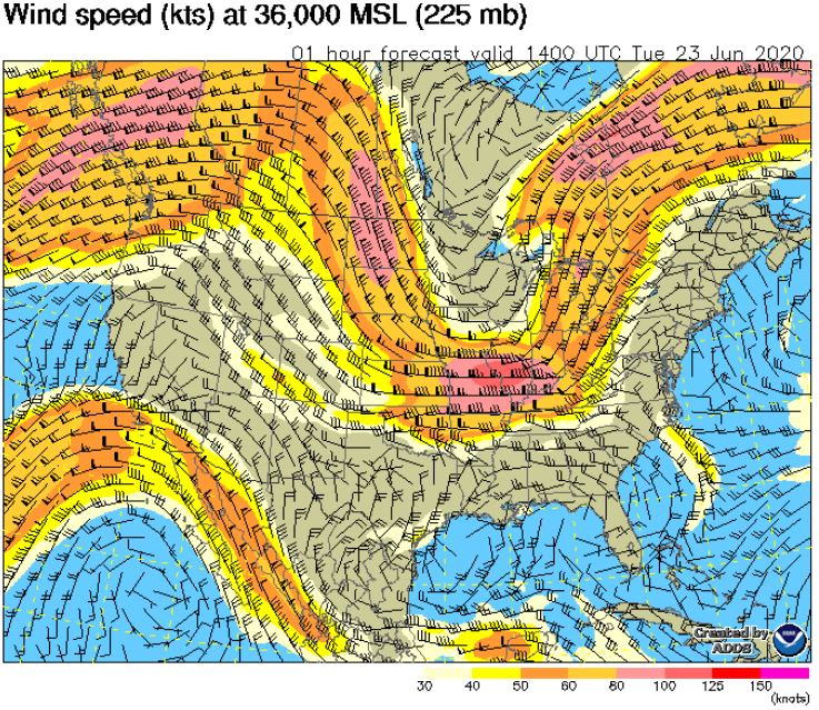
Here’s a video of the satellite this morning, in infrared. See the line of clouds forming and dissipating on a line down eastern Montana/Wyoming/NE Colorado? That’s the southwestern edge of the jet. There’s a screenshot of the plot at 36k feet after. Anywho, enjoy another beautiful day.

Monday morning, another day in Paradise

Once more, a day in our weather paradise.  Still that northwest flow aloft, on the edge of the jet stream coming down from Washington curling back to the east.  A little cooler today, still mid-80s. Scattered thunder bumpers around 5PM, this time south end of town out to DIA.  Notice, always DIA? Nice place to stick an airport, guys.  

Mostly blue skies until 5, scattered stuff at around 14k and 22k above us.  Around 5, a little later up toward Boulder, we’ll start to see the Care Bear clouds at around 8 thousand, covering most of the sky.  Along with the bumpers.

Tomorrow we’ll see more clouds and maybe some rain. Thunderbumpers, mostly along the front range, but doesn’t look like any severe stuff should get going. Sunshine and lolly pops for Wednesday, highs into the 90s.  

Sunday Morning, pleasant out there…

Well, a little more moisture moved in up high bringing us a more cloud cover than we were looking for. Starting around 1PM some bumpers up in the north end of the metro moving out to DIA. Soulth end should skate on getting bumpers. Those northern bumpers won’t be bad, mostly a little noise, and there’s not enough moisture to really get a good rain out of them.  

We’ll have cloud cover all day, scattered stuff around twelve thousand feet up, that’ll be the kind of fluffy ones, not quite Care Bear fluffy but fluffier than the ones that will be above at around twenty two thousand feet. That higher layer will be broken, which means covering most of the sky all day. Sounds like a cowboy song, doesn’t it?  Watching Blazing Saddles this morning, everything sounds like a cowboy song.  

Those thunder bumpers on the north side out to DIA will get going around 4ish, not bad ones, really, but the outflow from them will push air to the south too, so after 4PM winds will get occasionally gusty throughout the metro.  Higher terrain south—hello Park Meadows—will compress the escaping airmass so, like putting your finger over the end of a hose, the gusts will be worse down that way.  Maybe up to 35 knots.  Knots? Oh gee, that’ll be about 40 MPH.  A knot, nautical mile, is 6k feet versus our mile of 5280. Yeah, I don’t know, something caused by a bunch of rum-soaked navy dudes. I don’t think they could multiply complicated numbers.

We’ll still see mid to upper 80s on the temps.  Through Wednesday more of the same, clearing off to blue skies for a time Monday and Tuesday, bumpers toward afternoon. It’s a series of weak surface fronts and troughs moving through and the jet stream aloft holding steady just north of us, from the northwest.  Eastern Nebraska has some severe forecast today and tonight, so the weather channel will get some real drama going.     

Saturday morning, oh yeah it’s looking like Colorado

A little wind along the Palmer Divide and east around DIA this morning, not much downtown north. We’re going to call those drainage winds. The cold stuff left from the last couple days left in the mountains, heavier than the warm air coming in, escaping to lower ground.  Wind should be dying down pretty soon, not much for the rest of the day. It’s pretty, and going to stay that way today. Just a few high clouds and a lot of Colorado blue sky to keep us around. 10-20 degrees warmer today, so just on the warm side of pleasant. Mid-80s, yeah! Hey, we deserve it.  

And tomorrow much the same.  Some bumpers in the mountains and maybe along high points like the Palmer Ridge on the south end of town, but nothing significant.  

Pretty much the story for the southwest part of the continent. Big, big area of pretty.  Elsewhere not so much. Rain up in Washington and the normal line of scattered thunderstorms developing from Texas to Minnesota, fewer south end of that more north, and along the east coast.  Fewer south there, too.  

Tulsa

TwitLer’s warning to “…protesters, anarchists, agitators, looters or lowlifes…” Isn’t it already a rally for lowlifes?

Update Friday eve around 4ish

Still some bumpers around, raining here and there around the metro right now, should be cleaning out shortly after 5, just scattered clouds around 7 and a beautiful evening, dry tomorrow.